About Me

I am a PhD student at the Chair of Cartography and Visual Analytics at the Technical University of Munich, supervised by Prof. Liqiu Meng and mentored by Prof. Yu Feng. I came to AI from maps. I studied geodesy, cartography and GIS at Wuhan University, where I first used language models to make sense of geospatial code, and I now spend most of my time on the AI side of GeoAI. Besides research, I supervise Master’s students and maintain open learning resources on LLM agents and web scraping.

Education

PhD in Cartography

2025–present

Technical University of Munich

Supervisor Prof. Liqiu Meng · Mentor Prof. Yu Feng

M.Sc. in Cartography and GIS

2022–2025

Wuhan University

Supervisors Prof. Zhipeng Gui and Prof. Huayi Wu

B.Eng. in Geodesy and Geomatics Engineering

2018–2022

Wuhan University

Top 5% of the cohort by GPA

Research Interests

I am interested in how AI systems that reason about place can be built, checked and trusted. Much of my current work concerns LLM and multimodal agents that plan, call tools and verify their own results when analysing geospatial models, and how such agents can explain those models to people with different backgrounds. A related question is whether an explanation reflects what a model actually relies on, which I study with controlled experiments where the ground truth is known. I am also increasingly interested in location privacy, as multimodal models become able to infer where people are from the images and text they share.
LLM agents and multi-agent systems Multimodal agents Trustworthy and explainable AI Location privacy GeoAI Knowledge extraction and knowledge graphs

Publications

Peer-reviewed papers, with figures and code where available
Google Scholar profile

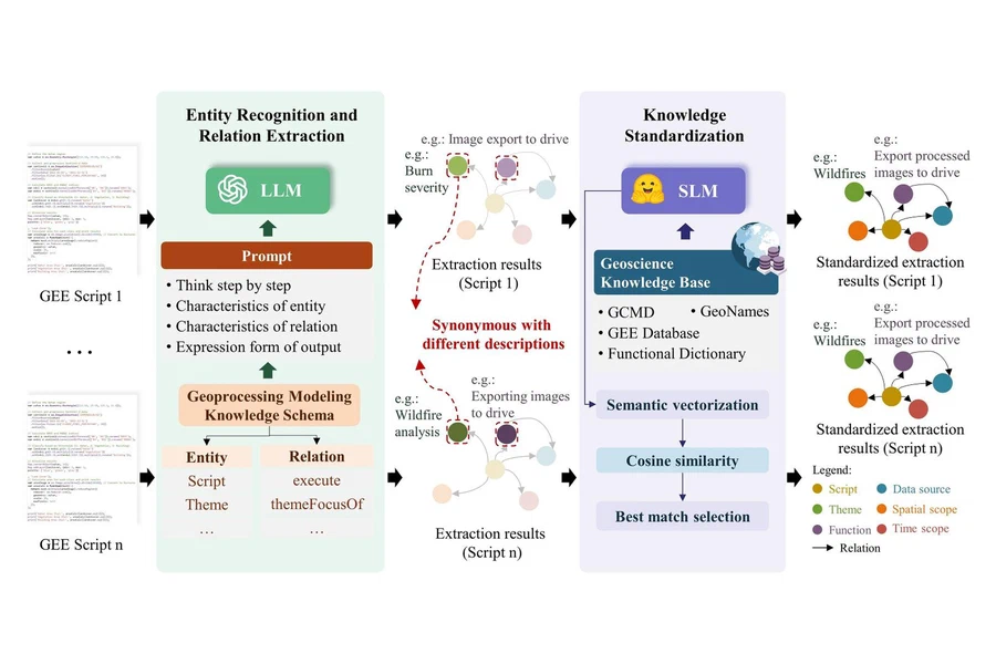
Geo-CLASS: Knowledge from Earth Engine Scripts
IJGIS 2026

Geo-CLASS: Knowledge from Earth Engine Scripts

Zhao A., Gui Z., Liang J., Liu Y., Peng D., Wei W., Hou S., Wu H.

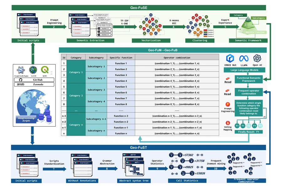
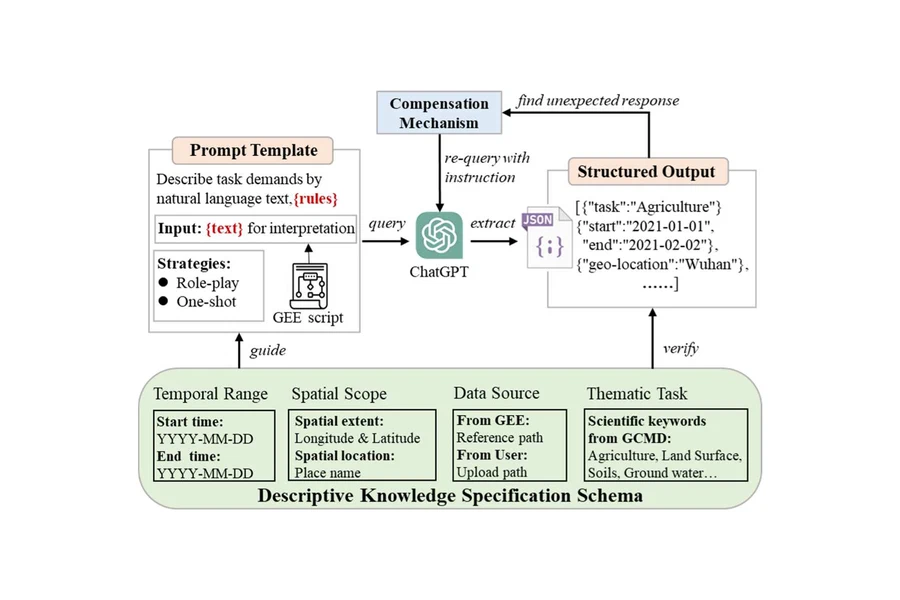
A pipeline that coordinates large and small language models to extract reusable geoprocessing modelling knowledge from crowdsourced Google Earth Engine scripts.

LLM + SLM coordination Chain-of-thought prompting Embedding-based ontology mapping Knowledge graphs
Distributed Clustering by Local Direction Centrality on Spark
Big Earth Data 2025

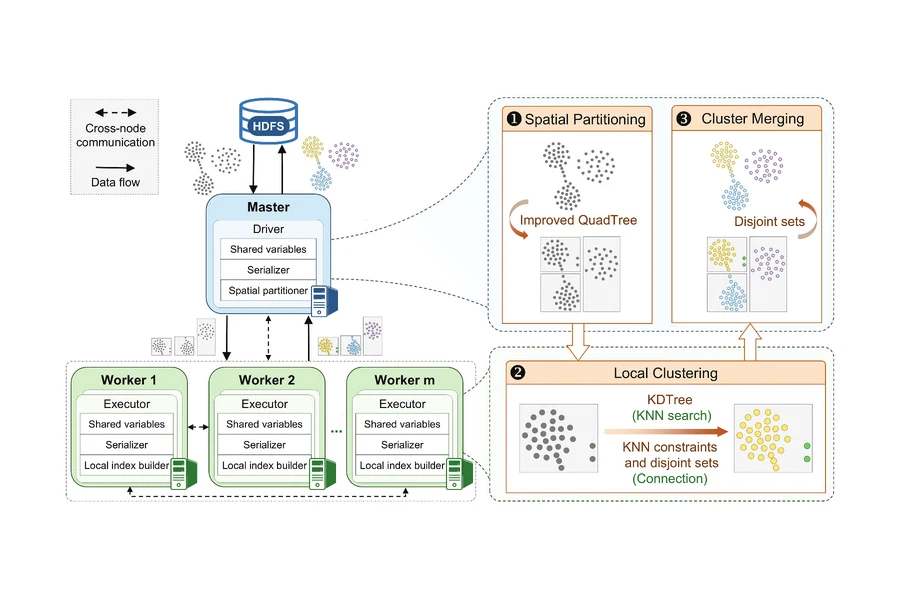
Distributed Clustering by Local Direction Centrality on Spark

Gui Z., Huang Z., Chen H., Peng D., Liu Y., Fang G., Lan Q., Zhao A., Wu H.

Parallelises the clustering-by-local-direction-centrality algorithm on Apache Spark with spatial partitioning and performance optimisations for large datasets.

Apache Spark Clustering HPC
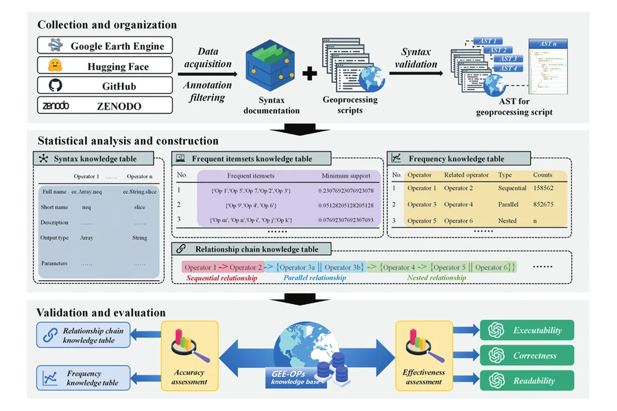
GEE-OPs: Operator Knowledge Base for Earth Engine Code
GSIS 2025

GEE-OPs: Operator Knowledge Base for Earth Engine Code

Hou S., Liang J., Zhao A., Wu H.

Mines operator call relationships from Earth Engine scripts with syntax-tree parsing and frequent-pattern analysis, forming a knowledge base that improves LLM code generation.

AST parsing Frequent patterns Code generation
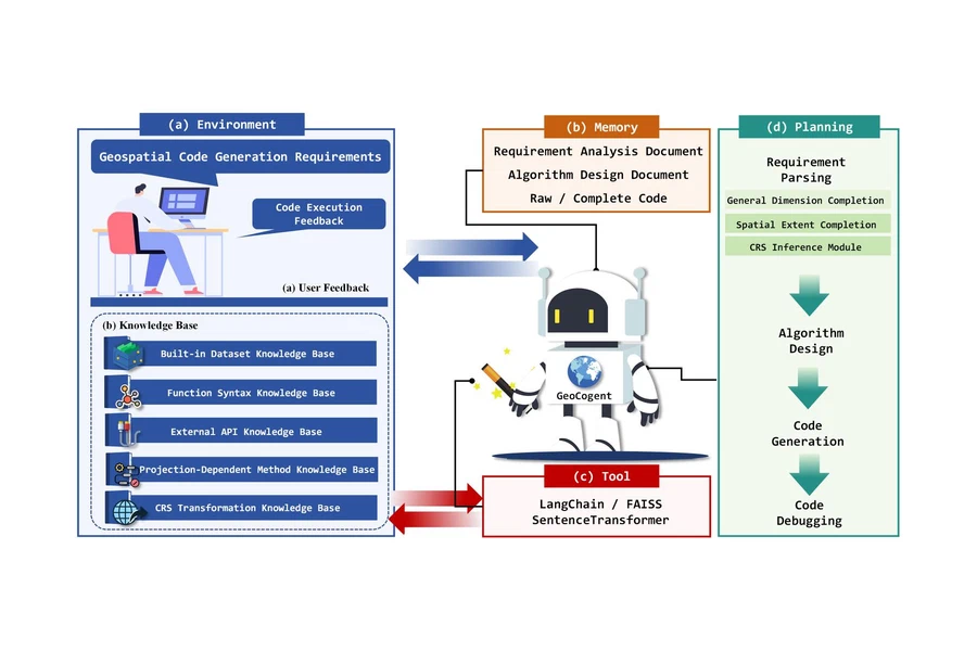
GeoCode-GPT: A Large Language Model for Geospatial Code
JAG 2025

GeoCode-GPT: A Large Language Model for Geospatial Code

Hou S., Shen Z., Zhao A., Liang J., Gui Z., Guan X., Li R., Wu H.

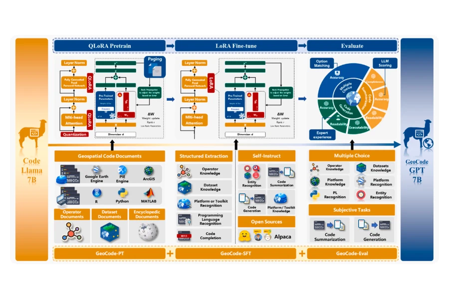
Fine-tunes an open LLM on purpose-built geospatial code corpora for pretraining, instruction tuning and evaluation, giving a model specialised in generating geospatial code.

Fine-tuning Code LLM Benchmark
Semantic-Driven Geospatial Modeling Knowledge Graph
GSIS 2025

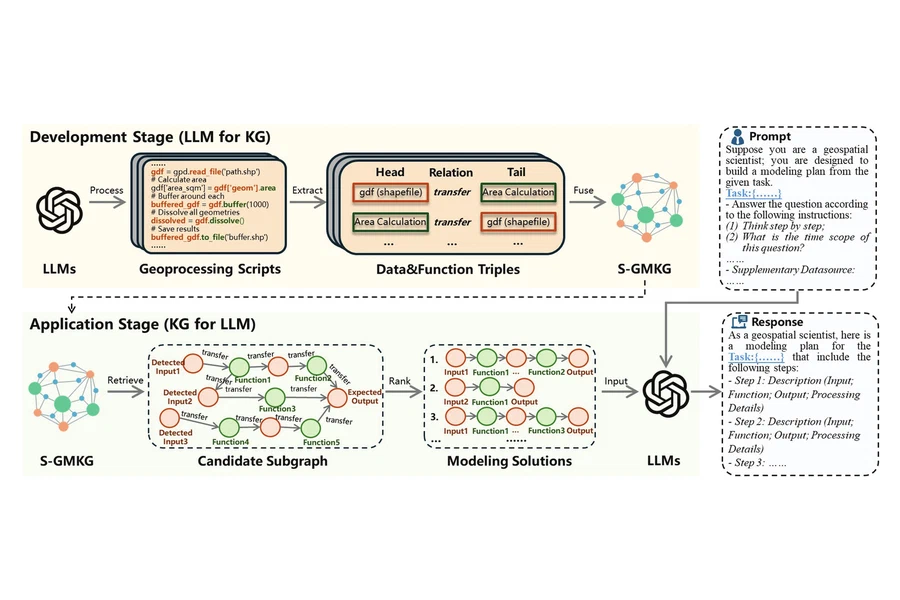
Semantic-Driven Geospatial Modeling Knowledge Graph

Liang J., Hou S., Zhao A., Xu Q., Xiang L., Li R., Wu H.

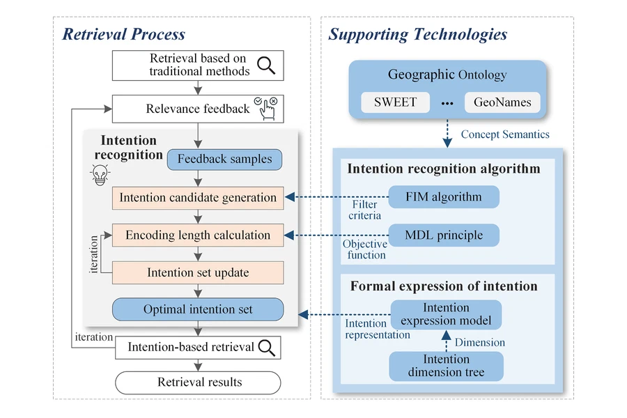
Designs a geospatial modeling knowledge graph whose entities and relations are extracted with LLMs, supporting semantic retrieval and recommendation of modeling knowledge.

Knowledge graph LLM extraction Recommendation
Trajectory Traits: Profiling Drivers from GPS Trajectories
Innovation Geoscience 2025

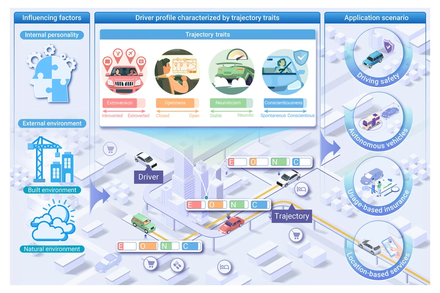
Trajectory Traits: Profiling Drivers from GPS Trajectories

Liu Y., Gui Z., Xu Y., Gao S., Zhao A., et al.

Introduces a Trajectory Trait Scale inspired by the five-factor personality model, scoring drivers’ extroversion, openness, neuroticism and conscientiousness from GPS trajectory features.

Trajectory mining Human mobility Driver profiling
GPT-Enhanced Knowledge Extraction for Earth Engine Models
IJDE 2024

GPT-Enhanced Knowledge Extraction for Earth Engine Models

Liang J., Zhao A., Hou S., Wu H., Jin F.

A GPT-assisted workflow that extracts structured knowledge about geographic analysis models from Google Earth Engine scripts and reuses it to support model construction.

GPT Knowledge extraction Earth Engine
Radiometric Normalisation of Cross-Sensor Gaofen Images
Remote Sensing 2021

Radiometric Normalisation of Cross-Sensor Gaofen Images

Yan L., Yang J., Zhang Y., Zhao A., Li X.

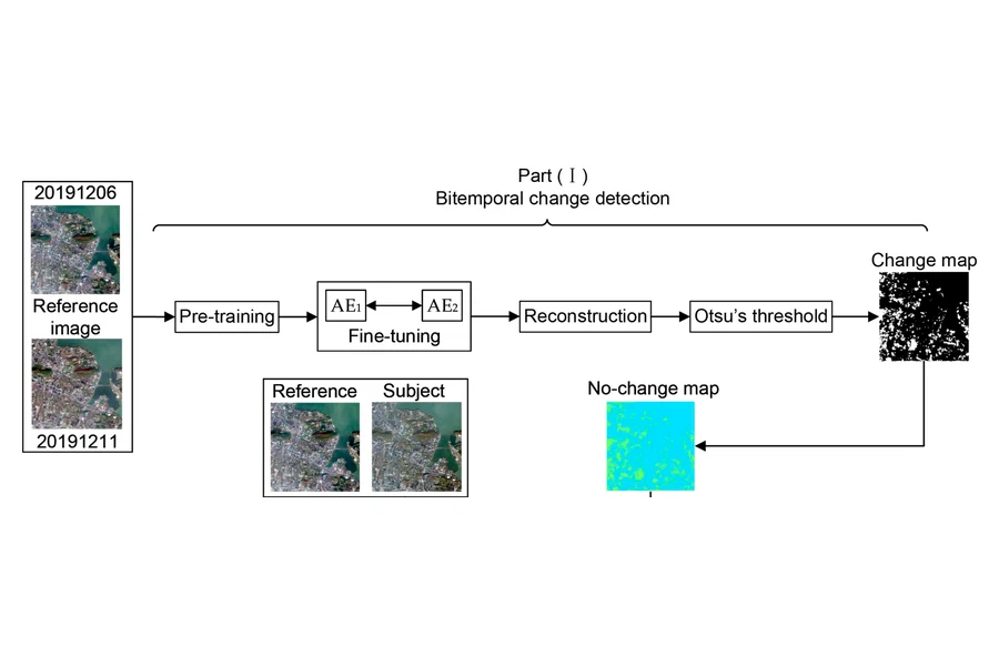
Normalises radiometry across Gaofen sensors by detecting unchanged pixels with change detection and a chi-square test, then fitting a relative normalisation model.

Remote sensing Change detection Statistics

Projects

Open-source projects on GitHub

LLM Agent Roadmap
Live

LLM Agent Roadmap

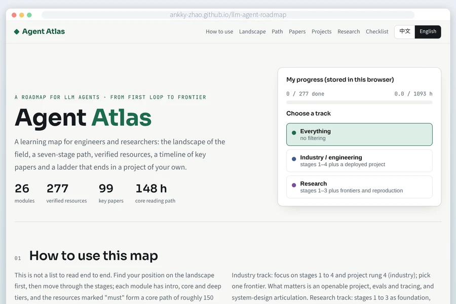
A bilingual learning map that takes readers from first contact with LLM agents to research topics and their own projects.

HTML JSON Python build script GitHub Pages
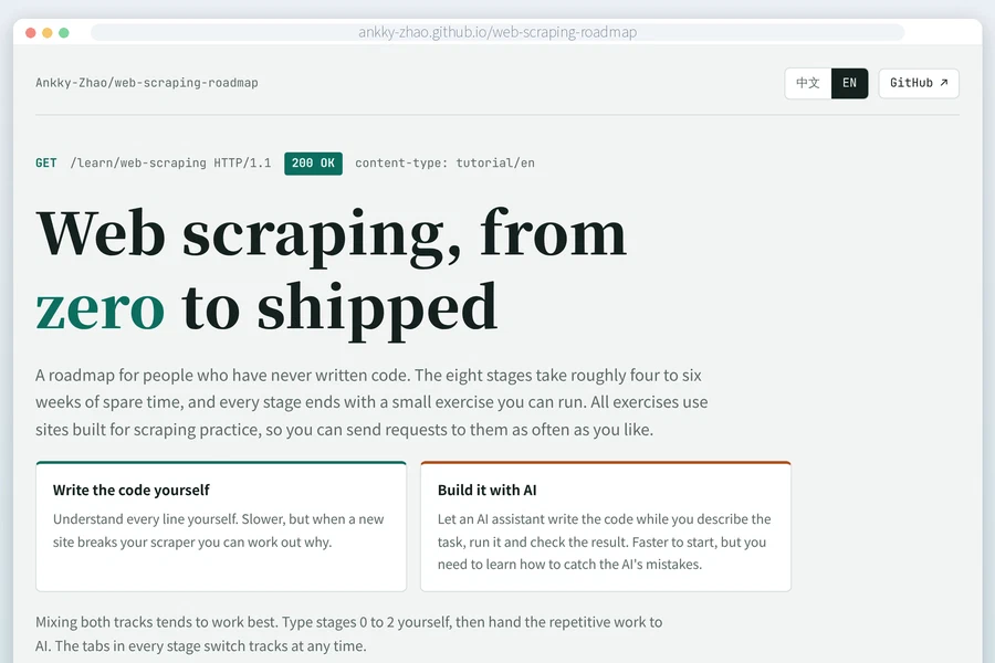
Web Scraping Roadmap
Live

Web Scraping Roadmap

A bilingual tutorial that goes from the first HTTP request to a complete scraping project, with both hand-written and AI-assisted code.

Python requests HTML parsing AI-assisted coding
News

Oct 2026 · Launched this website. I am open to collaboration on trustworthy AI and LLM agents, see Open to Collaboration.

Oct 2026 · Released the Web Scraping Roadmap, a bilingual guide from first request to a finished scraping project.

Sep 2026 · Released the LLM Agent Roadmap, an open learning map of LLM agents with curated resources and a key-papers timeline.

Nov 2025 · First-author paper on coordinating large and small language models for geoprocessing knowledge extraction published in IJGIS.

Sep 2025 · Started my PhD at the Chair of Cartography and Visual Analytics, TUM.

Teaching

Supervision · Master’s theses on benchmarking and evaluating explanations of geospatial AI.

Teaching · Topic design for the seminar Mapping for a Sustainable World, TUM. Earlier teaching assistant for the Artificial Intelligence Summer School at the University of Cambridge (2021), the International Geoinformatics Summer School (2022) and Data Structure and Programming in C++ (2024–2025) at Wuhan University.

Skills
AI and machine learning
LLM agents and multi-agent orchestration
Retrieval-augmented generation
Explainable AI (SHAP, uncertainty)
Knowledge graphs
Engineering
Python
PyTorch and Hugging Face Transformers
XGBoost and scikit-learn
Git and GitHub Actions
Geospatial
Spatial analysis and GIS
Google Earth Engine
Cartographic design
Honours
Outstanding Postgraduate of LIESMARS
Wuhan University ∙ 2024
Two granted Chinese invention patents
Knowledge-graph-based map retrieval ∙ 2023–2024
Outstanding Graduate
Wuhan University ∙ 2022
First Prize
National Surveying Science and Technology Thesis Competition for College Students ∙ 2021
National Inspirational Scholarship
Wuhan University ∙ 2019–2021
Languages
100%
Chinese Native
80%
English Fluent (IELTS 7.0)
60%
Japanese JLPT N3
20%
German Learning (A1)
Hobbies
🏸 Badminton💃 Dancing🥾 Hiking✈️ Travel
Recent Posts
Why I built an open learning map for LLM agents featured image

Why I built an open learning map for LLM agents

Notes on turning my own reading list into a public, bilingual roadmap.

Open to Collaboration

I would like to work with people who share an interest in trustworthy and explainable AI, LLM and multimodal agents and newer agent topics such as evaluation, reliability and reasoning, or location privacy in the age of AI. Projects close to GeoAI are welcome, and so are questions from the broader AI side where spatial data is one testbed among others. PhD students, postdocs and industry researchers are all welcome, for a joint paper, a dataset or benchmark, or an open-source tool. If this overlaps with your work, a short email about what you are working on is the best way to start.